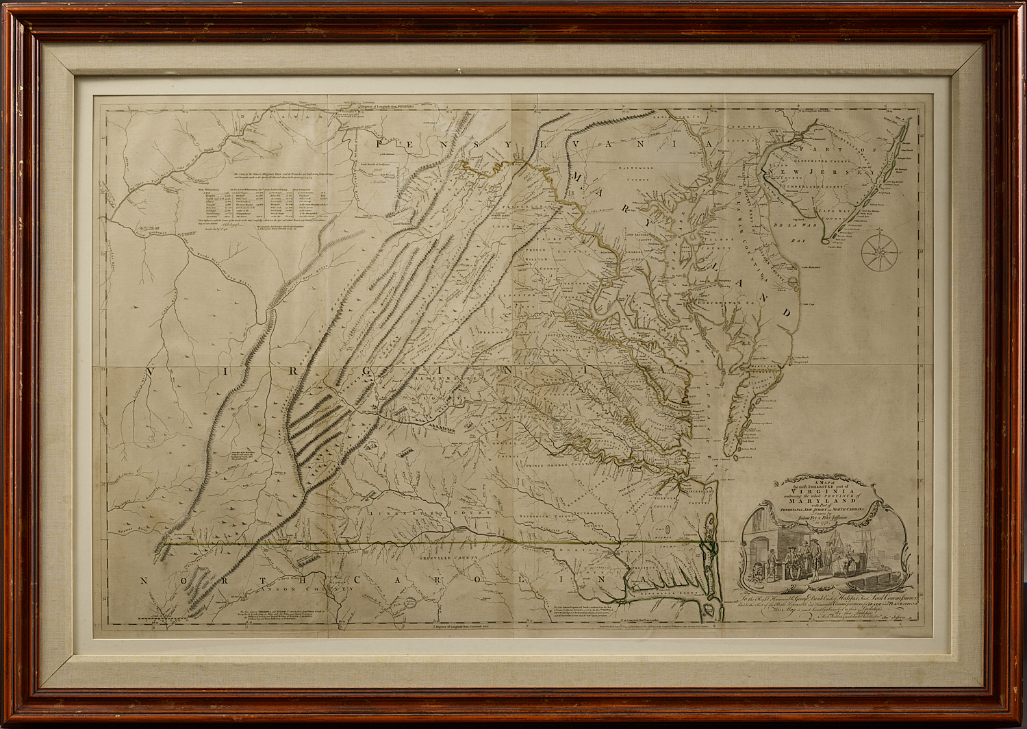
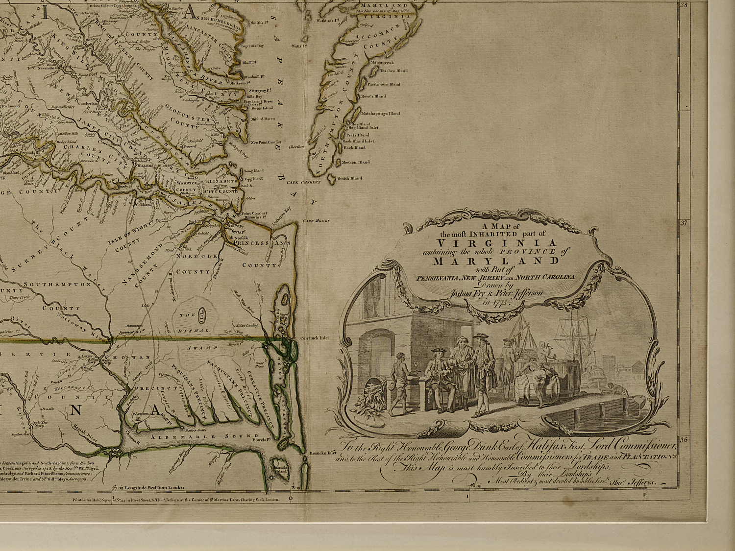
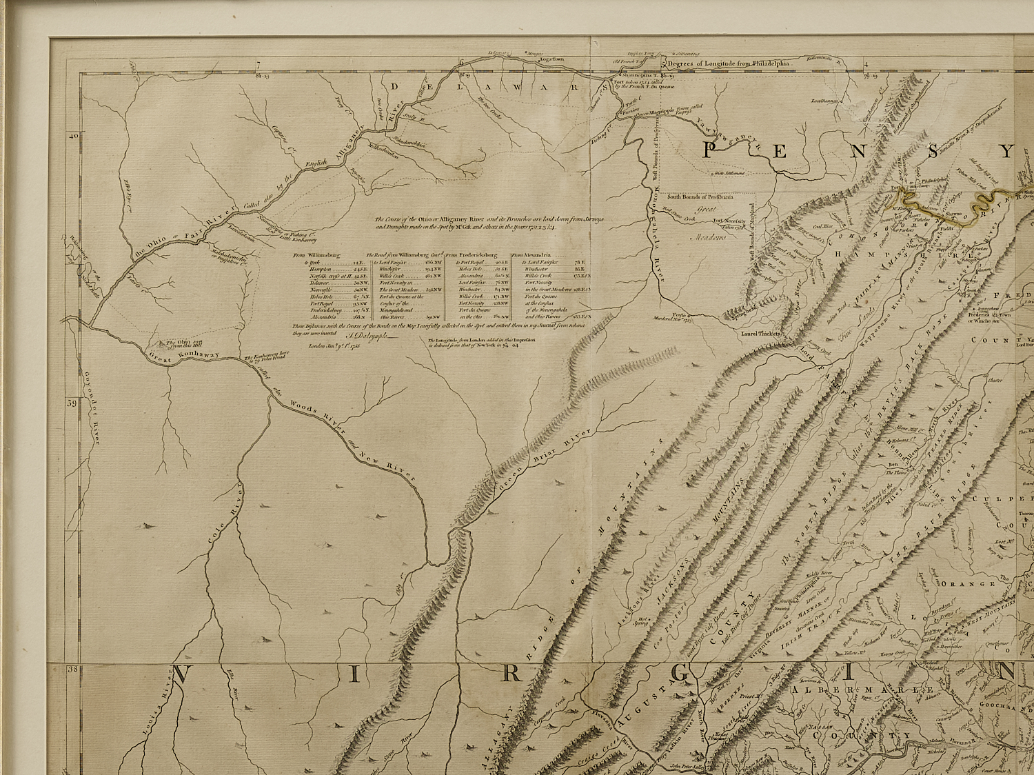
A Map of the most Inhabited part of Virginia containing the whole Province of Maryland … 1775.
FRY, Joshua, and Peter JEFFERSON.
London: Published by Thomas Jeffreys Geographer to His Royal Highness [1755.]
Engraved and printed on four joined folio sheets measuring ~ 30” x 48”. Framed – 42″ x 60″
Fry and Jefferson’s map is the most important map of Virginia of the eighteenth century and a landmark in the mapping of the colony and neighboring Maryland. It was the first of Virginia by Virginians; the first to accurately depict the Blue Ridge, and to lay down the colony’s road system. Many early plantations are located and identified by family name along the great rivers. The attractive cartouche depicts a tobacco warehouse and wharf and is one of the earliest printed images of the Virginia tobacco trade. The map remained the basis for all subsequent depictions of Virginia until the nineteenth century.
The map was commissioned by the English Lords of Trade, who in 1750 required each colony to conduct a comprehensive survey. Joshua Fry (1700-1754), a mathematician at the College of William and Mary, and Peter Jefferson (1708-1757), a surveyor and the father of Thomas Jefferson, who together had drawn the boundaries of Lord Fairfax’s lands in 1746 and surveyed the Virginia-North Carolina boundary in 1749, were appointed to execute the commission. Fry and Jefferson were the logical choices to make the map and were described by Governor Nathaniel Burwell as “the most able persons.”
The map was originally published in an unfinished state in 1753 on the eve of the French & Indian War. This heavily revised and updated version appeared in 1775, in Jefferys’ American Atlas, at the beginning of the American Revolution when interest in the colonies and their geography was high among the British public. It was the standard cartographic reference for Virginia during the war not only for the French forces, but for the American and British as well. Thomas Jefferson wrote to General Horatio Gates in 1780, “we are endeavouring to get you a copy of Fry & Jefferson’s [map]; but they are now very scarce.” George Washington owned a copy, now in the collection of Yale University.
Eight separate states of the Fry-Jefferson map have been identified. The four early states culminate in the issue of 1755, by which time all of the important geographical revisions were incorporated. In the four states subsequent to 1755, geographic detail was unchanged, but bibliographic detail (e.g. publisher’s imprint) varied. The first four states are so rare as to be virtually unobtainable. The present example is state 6, as identified by Coolie Verner, which differs from state 5 only by the date printed in the title (1775 instead of 1751), and from state 7, by a change in imprint (state 7 omits Jefferys’ address, which is included in state 6).
Some original outline color, minor signs of aging, generally excellent condition.
Ex Colonial Williamsburg Collection
References: Catalogue entries Ruderman Rare Maps & Donald Heald. Pritchard & Taliaferro, Degrees of Latitude, entries 30 and 64; Wooldridge, Mapping Virginia, Chapter 6 (pp. 107-121); Stephenson & McKee Virginia in Maps, Map II-21A-D, p. 83; Cumming, The Southeast in Early Maps, 281; Coolie Verner, “The Fry and Jefferson Map”, Imago Mundi XXI, pp. 70-94; cf. On the Map, Figure 42; Papenfuse & Coale, pp. 34-36; Schecter, George Washington’s America. A Biography Through his Maps, Yale George Washington Atlas, Maps 33-34.